Thematic mapping of Burundi using geospatial data and satellite images processed by geoinformatics methods
DOI:
https://doi.org/10.47456/geo.v4i39.46177Keywords:
remote sensing, mapping, satellite imagesAbstract
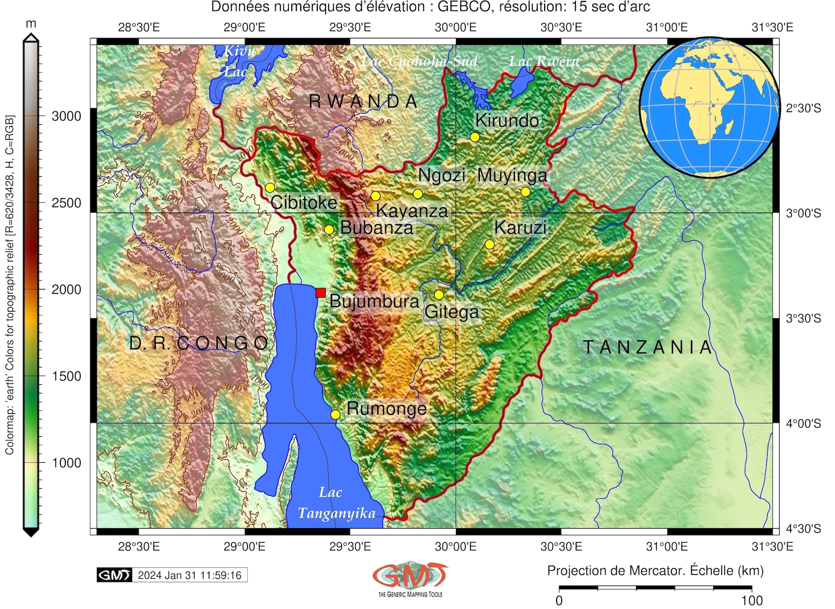
This paper presents the implementation of the integrated cartographic approach for environmental mapping of Burundi, East Africa. Monitoring different types of land cover in Africa by remote sensing is presented using GRASS SIG methods. The series of thematic maps of vegetation and habitat types, landscapes, topographic, geomorphic and geological context of Burundi is created in QGIS and GMT software. The methodological issues concerning the processes of cartographic scripting are discussed with commented snippets of programming codes using syntax of GRASS GIS. Several modules are used for satellite image mosaic, processing vector and raster data, and classification. The paper documents environmental features of Burundi, such as vegetation types, land cover patterns, geologic setting and landscape distribution using digital cartographic tools. A series of the thematic maps is proposed to support environmental policies on agricultural management in Burundi.
Downloads
References
BETGE, D. A Holistic Approach to Address Food Security Risks and Climate Change Adaptation—Insights from Burundi. In: Leal Filho, W., Djekic, I., Smetana, S., Kovaleva, M. (eds) Handbook of Climate Change Across the Food Supply Chain. Climate Change Management. Springer, Cham, 2022. https://doi.org/10.1007/978-3-030-87934-1_20
BUNUNU, Y. A.; BELLO, A.; AHMED, A. Land cover, land use, climate change and food security. Sustainable Earth Reviews, v. 6, n. 16, 2023. https://doi.org/10.1186/s42055-023-00065-4
BUYSE, F.; DEWAELE, S.; DECRÉE, S.; MEES. F. Mineralogical and geochemical study of the rare earth element mineralization at Gakara (Burundi). Ore Geology Reviews, v. 124, n. 103659, 2020. https://doi.org/10.1016/j.oregeorev.2020.103659
CABRAL, A. I. R.; VASCONCELOS, M. J. P.; PEREIRA, J. M. C.; MARTINS, E.; É. BARTHOLOMÉ. A land cover map of southern hemisphere Africa based on SPOT-4 Vegetation data. International Journal of Remote Sensing, v. 27, n. 6, p. 1053-1074, 2006. https://doi.org/10.1080/01431160500307409
CHUWA, G. L.; KASANZU, C. H.; APEN, F. E.; KAZIMOTO, E. O. Geochemistry and U–Pb zircon geochronology of S-type granites in the Karagwe Ankolean Belt, northwestern Tanzania: Implications for rare-metals mineralization. Journal of African Earth Sciences, v. 208, n. 105078, 2023. https://doi.org/10.1016/j.jafrearsci.2023.105078
CLOETE, D. N.; SHOKO, C.; DUBE, T.; SUMAYA C. Remote sensing-based land use land cover classification for the Heuningnes Catchment, Cape Agulhas, South Africa. Physics and Chemistry of the Earth, Parts A/B/C, v. 103559, 2024. https://doi.org/10.1016/j.pce.2024.103559
CUQ, F. Actes des journées. Télédétection en Sciences Humaines », Cybergeo: European Journal of Geography [En ligne], Dossiers, 2009. https://doi.org/10.4000/cybergeo.614
DECRÉE, S.; BOULVAIS, P.; COBERT, C.; BAELE, J.-M.; MIDENDE, G.; GARDIEN, V.; TACK, L.; NIMPAGARITSE, G.; DEMAIFFE, D. Structurally-controlled hydrothermal alteration in the syntectonic Neoproterozoic Upper Ruvubu Alkaline Plutonic Complex (Burundi): Implications for REE and HFSE mobilities. Precambrian Research, v. 269, p. 281-295, 2015. https://doi.org/10.1016/j.precamres.2015.08.016
DIÉDHIOU, I.; MERING, C.; SY, O.; TIDIANE, S. Cartographier par télédétection l’occupation du sol et ses changements. EchoGéo [En ligne], v. 54, 2020. https://doi.org/10.4000/echogeo.20510
EJIGU, M. Environmental Scarcity, Insecurity and Conflict: The Cases of Uganda, Rwanda, Ethiopia and Burundi. In: BRAUCH, H.G., et al. Facing Global Environmental Change. Hexagon Series on Human and Environmental Security and Peace, v. 4. Springer, Berlin, Heidelberg, 2009. https://doi.org/10.1007/978-3-540-68488-6_68
EL-AWADY, M. M.; EL-BADRAWY, H. T.; ABUO EL-ELA, A. M.; SOLIMAAN, M. R.; ALREFAEE, H. A.; ELBOWAB, M. Integrated geophysical studies on the area east of Abu Gharadig basin, southern Cairo, Egypt, using potential field data. NRIAG Journal of Astronomy and Geophysics, v. 5, n. 2, p. 351-361, 2016. https://doi.org/10.1016/j.nrjag.2016.05.002
EL-HASSANIN, A. S.; LABIB, T. M.; GABER, E. I. Effect of vegetation cover and land slope on runoff and soil losses from the watersheds of Burundi. Agriculture, Ecosystems & Environment, v. 43, n. 3, p. 301-308, 1993. https://doi.org/10.1016/0167-8809(93)90093-5
EMISHAW, L.; ABDELSALAM, M. G. Satellite gravity data for mapping lithospheric structure of Precambrian tectonic blocks in Africa: The advantages and limitations. Journal of African Earth Sciences, v. 197, n. 104775, 2023. https://doi.org/10.1016/j.jafrearsci.2022.104775
EVANS, D. M. Metamorphic modifications of the Muremera mafic–ultramafic intrusions, eastern Burundi, and their effect on chromite compositions. Journal of African Earth Sciences, v. 101, p. 19-34, 2015. https://doi.org/10.1016/j.jafrearsci.2014.09.004
FIKADU, G.; OLIKA G. Impact of land use land cover change using remote sensing with integration of socio-economic data on Rural Livelihoods in the Nashe watershed, Ethiopia. Heliyon, v. 9, n. 3, p. e13746, 2023.
GE, J.; QI, J.; LOFGREN, B. Use of vegetation properties from EOS observations for land-climate modeling in East Africa. Journal of Geophysical Research, v. 113, n. D15101, 2008. https://doi.org/10.1029/2007JD009628
HENRI, N. Progrès de la connaissance du Congo, du Rwanda et du Burundi de 1993 à 2008. Belgeo, v. 3-4, 2009. https://doi.org/10.4000/belgeo.7306
HENNEBERT, P. A.; TESSENS, E.; TOURENNE, D.; DELVAUX, B. Validation of a FAO land evaluation method by comparison of observed and predicted yields of five food crops in Burundi. Soil Use and Management, v. 12, p. 134-142, 1996. https://doi.org/10.1111/j.1475-2743.1996.tb00534.x
HICINTUKA, C.; MASILYA, P. M. Gestion optimale et intégrée de la fertilité des sols acides du Burundi. VertigO, v. 17, 2013. https://doi.org/10.4000/vertigo.13898
KIM, D.-Y.; THOMAS, V.; OLSON, J.; WILLIAMS, M.; CLEMENTS, N. Statistical trend and change-point analysis of land-cover-change patterns in East Africa. International Journal of Remote Sensing, v. 34, n. 19, p. 6636-6650, 2013. DOI: https://doi.org/10.1080/01431161.2013.804224
LEMENKOVA, P. Using open-source software GRASS GIS for analysis of the environmental patterns in Lake Chad, Central Africa. Die Bodenkultur: Journal of Land Management, Food and Environment, v. 74, n. 1, p. 49-64, 2023a. https://doi.org/10.2478/boku-2023-0005
LEMENKOVA, P. A GRASS GIS Scripting Framework for Monitoring Changes in the Ephemeral Salt Lakes of Chotts Melrhir and Merouane, Algeria. Applied System Innovation, v. 6, n. 4, p. 61, 2023b. https://doi.org/10.3390/asi6040061
LEMENKOVA, P. Monitoring Seasonal Fluctuations in Saline Lakes of Tunisia Using Earth Observation Data Processed by GRASS GIS. Land, v. 12, n. 11, p. 1995, 2023c. https://doi.org/10.3390/land12111995
LEMENKOVA, P.; DEBEIR, O. R Libraries for Remote Sensing Data Classification by K-Means Clustering and NDVI Computation in Congo River Basin, DRC. Applied Sciences, v. 12, n. 24, p. 12554, 2022a. https://doi.org/10.3390/app122412554
LEMENKOVA, P.; DEBEIR, O. Satellite Image Processing by Python and R Using Landsat 9 OLI/TIRS and SRTM DEM Data on Côte d’Ivoire, West Africa. Journal of Imaging, v. 8, n. 12, p. 317, 2022b. https://doi.org/10.3390/jimaging8120317
LEMENKOVA, P.; DEBEIR, O. Coherence of Bangui Magnetic Anomaly with Topographic and Gravity Contrasts across Central African Republic. Minerals, v. 13, n. 5, p. 604, 2023a. https://doi.org/10.3390/min13050604
LEMENKOVA, P.; DEBEIR, O. Multispectral Satellite Image Analysis for Computing Vegetation Indices by R in the Khartoum Region of Sudan, Northeast Africa. Journal of Imaging, v. 9, n. 5, p. 98, 2023b. https://doi.org/10.3390/jimaging9050098
LWASA, S. Appreciating the heterogeneity in the unity of Africa: A socio-ecological perspective on Africa's geographies. The Canadian Geographer / Le Géographe canadien, v. 63, p. 594-602, 2019. https://doi.org/10.1111/cag.12576
MASWI, M. S.; ELISANTE E. M. Remote sensing mapping of geothermal systems around Lake Natron in the east Africa rift system, northeastern Tanzania. Geothermics, v. 119, n. 102930, 2024. https://doi.org/10.1016/j.geothermics.2024.102930
MIDENDE, G.; BOULVAIS, P.; TACK, L.; MELCHER, F.; GERDES, A.; DEWAELE, S.; DEMAIFFE, D.; DECRÉE, S. Petrography, geochemistry and U–Pb zircon age of the Matongo carbonatite Massif (Burundi): Implication for the Neoproterozoic geodynamic evolution of Central Africa. Journal of African Earth Sciences, v. 100, p. 656-674, 2014. https://doi.org/10.1016/j.jafrearsci.2014.08.010
NDAGIJIMANA, M.; KESSLER, A.; ASSELDONK, M. Understanding farmers' investments in sustainable land management in Burundi: A case-study in the provinces of Gitega and Muyinga. Land Degradation & Development, v. 30, n. 417–425, 2019. https://doi.org/10.1002/ldr.3231
NIRAGIRA, S.; D’HAESE, M.; BUYSSE, J. et al. Historical changes in the traditional agrarian systems of Burundi: endogenous drive to survive from food insecurity. GeoJournal, v. 86, p. 865–884, 2021. https://doi.org/10.1007/s10708-019-10102-5
NIRAGIRA, S.; NDIMUBANDI, J.; VAN ORSHOVEN, J. et al. Modelling crop portfolios that minimize human macronutrient deficiency on subsistence farms in Burundi. Food Security, v. 14, p. 23–37, 2022. https://doi.org/10.1007/s12571-021-01216-1
NKUNZIMANA, A.; BI, S.; ALRIAH, M. A. A.; ZHI, T.; KUR, N. A. D. Comparative analysis of the performance of satellite-based rainfall products over various topographical unities in central East Africa: Case of Burundi. Earth and Space Science, v. 7, n. e2019EA000834, 2020. https://doi.org/10.1029/2019EA000834
NYIRARWASA, A.; HAN, F.; YANG, Z.; MPEREJEKUMANA, P.; DUFATANYE, UMWALI E.; NSENGIYUMVA, J. N.; HABIBULLOEV, S. Evaluating the Impact of Environmental Performance and Socioeconomic and Demographic Factors on Land Use and Land Cover Changes in Kibira National Park, Burundi. Sustainability, v. 16, n. 2, p. 473, 2024. https://doi.org/10.3390/su16020473
PEYROT, B. Dynamiques paléoécologique et anthropogène de la forêt ombrophile de la dorsale Congo-Nil au Burundi. Les Cahiers d’Outre-Mer, v. 199, pp. 271-292, 1997. https://doi.org/10.3406/caoum.1997.3656
PLACIDE, G.; LOLLCHUND, M. R.; DALSO, G. A. Wind Energy Potential Assessment of some Sites in Burundi using Statistical Modelling, 2021 IEEE PES/IAS PowerAfrica, Nairobi, Kenya, p. 1-5, 2021. https://doi.org/10.1109/PowerAfrica52236.2021.9543186
SELLIN, V.; MAGNANON, S.; GOURMELON, F.; DEBAINE, F.; NABUCET. J. Etude expérimentale en cartographie de la végétation par télédétection. Cybergeo: European Journal of Geography, Cartographie, Imagerie, SIG, v. 730, 2015. DOI: https://doi.org/10.4000/cybergeo.27067
ROBERT, E.; GANGNERON, F. Un « SIG à dires d’acteurs » : décryptage des vulnérabilités environnementales des agro-éleveurs et pasteurs au Bénin. Cybergeo: European Journal of Geography [En ligne], Cartographie, Imagerie, SIG, v. 748, 2015. https://doi.org/10.4000/cybergeo.27285
TURIMUBUMWE, P.; ADAM, A. G.; ALEMIE, B. K. Managing public urban lands for sustainable urban development in Bujumbura, Burundi: The role of land administration system. GeoJournal, v. 89, p. 10, 2024. https://doi.org/10.1007/s10708-024-10998-8

Published
How to Cite
Issue
Section
License
Copyright (c) 2024 Geografares

This work is licensed under a Creative Commons Attribution 4.0 International License.
Copyrights Declaration
Authors who publish in the journal agree with the following terms:
- Authors will keep their copyrights and grant the journal the right to their first publishing, simultaneously licenced under Creative Commons Attribution License which allows sharing their work with authorship recognition and initial release through this journal.
- Authors may sign additional contracts separately diffusing a non-exclusively version of the paper published in this journal (i.g. publishing in institutional repository or as a book chapter), once citing the authorship and initial release through this journal.
- Authors are encouraged to publicize and diffuse their paper online, for example onto institutional repositories or on their personal websites.


