Use of a remote piloted aircraft (RPA) to manage a building work
DOI:
https://doi.org/10.47456/bjpe.v8i4.38145Keywords:
RPA, Building work, Cartographic Precision, Change DetectionAbstract
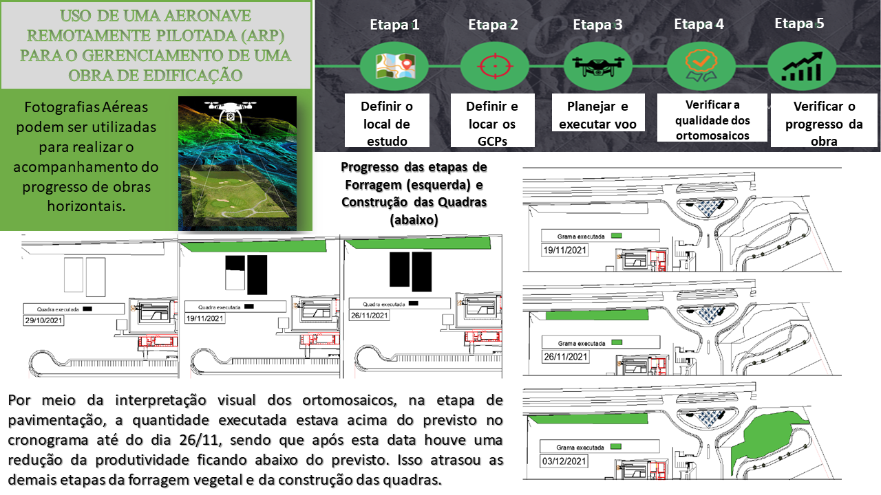
Images collected with a Remotely Piloted Aircraft (ARP) can be used to detect changes and monitor the progress of a work. We sought to evaluate the potential of orthomosaics for monitoring building work. For this, 4 flights were carried out from 10/29/2021 to 12/03/2021, at 1 pm, with a Mavic 2 Pro model ARP in an enterprise located in the municipality of Eusébio-CE. The planimetric errors of the four flights ranged from 66 to 69 cm and the altimetric errors from 25 cm to 49 cm. Subsequently, in the AutoCad software, the four orthomosaics were interpreted so as to carry out the monitoring of the progress of the stages of paving, grass settlement and construction of the blocks. As a result, it was noticed that after 11/26 the paved area was below schedule, leading to delays in the other stages of the work. The Spectral Angle Difference (SAD) and Multivariate Alteration Detection (MAD) algorithms were also applied for change detection analysis, whereby both algorithms had errors greater than 40%, making the use of these algorithms impracticable to monitor the work.
Downloads
References
Ellenberg, A., Branco, L., Krick, A., Bartoli, I., & Kontsos, A. (2014) Use of unmanned aerial vehicle for quantitative infrastructure evaluation. Journal of Infrastructure Systems, 21(3). https://doi.org/10.1061/(ASCE)IS.1943-555X.0000246 DOI: https://doi.org/10.1061/(ASCE)IS.1943-555X.0000246
Espartel, L. (2019). Curso de Topografia. 9 ed. Rio de Janeiro, Globo, 1987.
Greenwood, W. W., Jerome, P. L., & Dimitrios, Z. (2019). Applications of UAVs in Civil Infrastructure. Journal of Infrastructure Systems, 25(2). https://doi.org/10.1061/(ASCE)IS.1943-555X.0000464 DOI: https://doi.org/10.1061/(ASCE)IS.1943-555X.0000464
Irizarry, J. & Costa, D. B. (2016). Exploratory Study of potential Applications of Unmanned Aerial Systems for Construction Management Tasks. Journal of Management in Engineering, 32(3). https://doi.org/10.1061/(ASCE)ME.1943-5479.0000422 DOI: https://doi.org/10.1061/(ASCE)ME.1943-5479.0000422
Kruse, F. A., Lefkoff, A. B., & Boradman, J. W. (1993). The Spectral Image Processing System (SIPS) - Interactive Visualization and Analysis of Imaging Spectrometer Data. Remote Sensing of Environment, 44, 145-163. https://doi.org/10.1016/0034-4257(93)90013-N DOI: https://doi.org/10.1016/0034-4257(93)90013-N
Lin, Z., Stamnes, S., Jin, Z., Laszlo, I., Tsay, S., Wiscombi, W., & Stammes, K. (2015). Improved discrete ordinate solutions in the presence of an anisotropically reflecting lower boundary: Upgrades of the DISORT computational tool. Journal of Quantitative Spectroscopy and Radiative Transfer, 157, 119-134. https://doi.org/10.1016/j.jqsrt.2015.02.014 DOI: https://doi.org/10.1016/j.jqsrt.2015.02.014
Maply. Site oficial Maply. Recuperado de https://www.maply.io/
Nielsen, A. A., Conradsen, K., & Simpson, J. J. (1998). Multivariate Alteration Detection (MAD) and MAF Postprocessing in Multispectral, Bitemporal Image Data: New Approaches to Change Detection Studies. Remote Sensing of Environment, 64, 1-19. https://doi.org/10.1016/S0034-4257(97)00162-4 DOI: https://doi.org/10.1016/S0034-4257(97)00162-4
Ruy, R. S., Tommaselli, A. M. G., & Reis, T. T. (2007). Sistema aerotransportado leve de aquisição de imagens digitais – SAAPI. In: Anais XIII Simpósio Brasileiro de Sensoriamento Remoto, Florianópolis, Brasil, 21-26 abril 2007, INPE, 1329-1335.
Siebert, S., & Teizer, J. (2014). Mobile 3D mapping for surveying earthwork projects using an unmanned aerial vehicle (UAV) system. Automation in Construction, 41,1–14. https://doi.org/10.1016/j.autcon.2014.01.004 DOI: https://doi.org/10.1016/j.autcon.2014.01.004
Zhou, S., & Gheisari, M. (2018). Unmanned aerial system applications in construction: a systematic review. Construction Innovation, 18(4), 453-468. https://doi.org/10.1108/CI-02-2018-0010 DOI: https://doi.org/10.1108/CI-02-2018-0010
Downloads
Published
How to Cite
Issue
Section
License
Copyright (c) 2022 Brazilian Journal of Production Engineering

This work is licensed under a Creative Commons Attribution-NonCommercial-ShareAlike 4.0 International License.